On 16 September 1952, S J Bassett of the Naval Intelligence Department filed a memorandum. He records that in August 1946 the Joint Intelligence Committee had received a request from the US Chief of Naval Operations for a topographical survey of Britain’s coastline and beaches[ref]ADM 326/1314[/ref]. With the advent of the Cold War, the Americans feared that Britain might be invaded by Russian forces. Information about Britain’s beaches would be vital for an American counter invasion from the sea.
According to Bassett, Chiefs of Staff Committee approved a comprehensive coastal survey in August 1946. It would gather information about onshore and seabed conditions, beach gradients and sea depth. The information, that is, that would be essential to mounting a counter invasion.
The survey was given the code name ‘Operation Sandstone’. In 1951, the Chief of Combined Operations, Major-General Godfrey Wildman-Lushington, reported that work was progressing on the survey. However, beach reconnaissance methods were ‘slow, costly and not applicable to areas to which we had no access'[ref]ADM 326/1316[/ref].
Nevertheless, Operation Sandstone continued into the mid-1960s. By then most of Britain’s coast had been surveyed. It’s not easy to find out a great deal about the organisation and methods of the operation. Its secret nature meant that recorded discussion was minimal. There are a few administrative files in ADM 326, where the records are now held, which mention occasional discussion by the Joint Intelligence Committee.
Writing a detailed history of Operation Sandstone would be difficult. On the other hand, the records of the survey include many thousands of photographs, maps and pages of description. They provide a rich record of the coast as it was in the 1950s.
These records are now held in catalogue series ADM 326.They are generally organised by the area covered. For example, the 41 files between ADM 326/1070 and ADM 326/1100 cover the Norfolk coast between King’s Lynn and Cromer. This section is divided into 12 beaches, designated with the letters A to L, but they are not given a name.
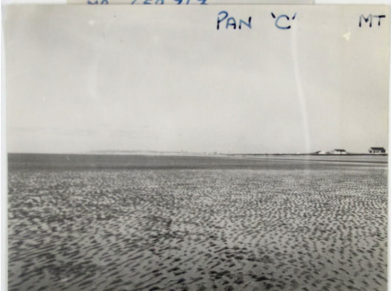
Perhaps some of our readers might be able to identify Beach B, which appears in the photographs that follow. I think this is around Snettisham, but I’m not entirely sure.
For each beach, the surveyors numbered observations points on a map as shown in this image.
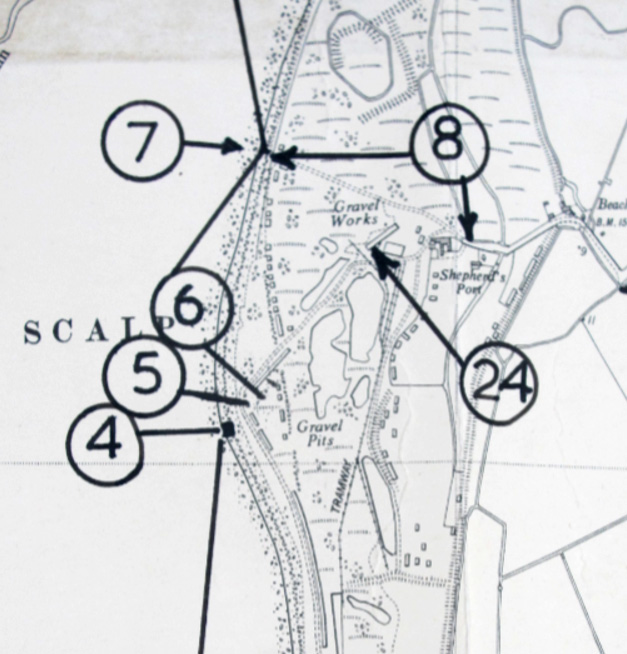
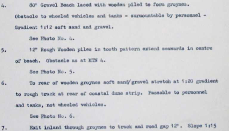
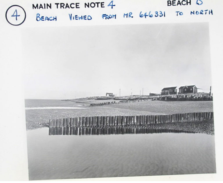
A description of each point marked on the maps is also given in ADM 326/1074. For example, surveyors described point 4 as ‘80’ gravel beach laced with wooden piles to form groynes. Obstacles to wheeled vehicles and tanks – surmountable by personnel. Gradient 1:12 soft sand and gravel. See photo no. 4”.
We find the associated photograph number 4 in file ADM 326/1086 under the heading ‘main tracings’.
Similarly, another photograph shows the wooden piles in tooth patterns extending seawards in the centre of the beach as described at point 5.
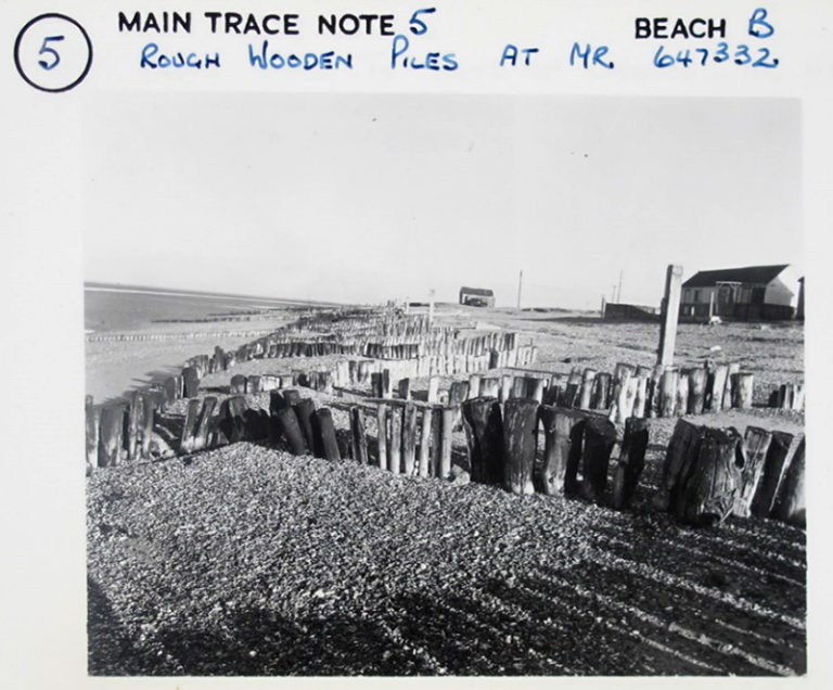
I am mystified by what might be a grid reference with an MR prefix in these photographs. It seems not to correspond to the Ordnance Survey National Grid or the older Cassini grid system, which I believe was in use at that time. The ‘point’ photographs are accompanied by wider ‘pan’ photographs. These show the wider scene, though it is more difficult to see the detail.
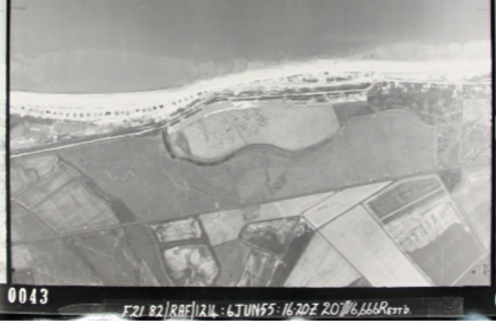
The section also includes a set of vertical aerial photographs, which appear to cover the whole coastline in a set of overlapping views. The photographs are of good quality and a substantial amount of the immediate hinterland is included. The photographs here are also of the coast between King’s Lynn and Cromer.
The series also includes a set of ‘oblique’ aerial photographs. These were taken at an angle to the vertical as the camera moved along the coast. Again there is overlap of around 50 per cent, so that all of the coast appears once in the more detailed foreground of one photograph, as well as in the background of another. They seem to be taken from a lower altitude.
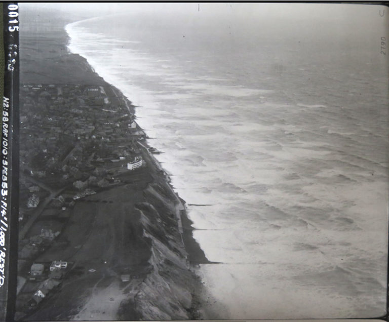
The aerial photographs are numbered, making them easy to put in order. To link these with the ‘point’ photographs of beaches would take a good deal of work, but would be possible. Because each photograph has an overlap with the following one, they present a continuous picture of much of the British coast.
Operation Sandstone finished in 1966, but not before it had produced a rich photographic and descriptive record of the British coast. The survey was fortunately never required for its original purpose and its records remained in storage. Following an extensive conservation and cataloguing project at The National Archives, they were made available to the public.
They might yet have an important role for environmental studies, as they give a comprehensive picture of the coast as it was in the 1950s. Assembled and presented digitally, they might provide an important marker for coastal change over the last sixty years. We would also be very interested to know if any of our readers can identify the places in the photographs.
Another fascinating post on a lesser known Cold War topic – one that although readers may be familiar with in regard to Allied surveys of Second World War landing beaches, they may not be familiar with in this context.
Although a major aspect of the Cold War can be seen as intelligence gathering in the hope that a shooting war wouldn’t occur – or if it did it would be ‘your’ that would be victorious – there was a wide-spread fear of potential conflict and invasion.
This is perhaps one of the reasons that both the USA and USSR were keen to ensure that Europe would be the major battleground.
Rumours were heard of Warsaw Pact special forces personnel disguised as lorry drivers travelling the roads of potential European enemies gathering useful information.
No doubt a reader in one of these countries would tell similar stories of NATO intelligence gathering.
It would be interesting to see if the National Archives could shed any light – positive or otherwise – on these stories.
MR prefix: As this was a naval project dealing with potential landings from the sea could the reference be connected to Admiralty Nautical Charts?
Just a random and uninformed thought…
I wonder if these will ever be of use towards meeting the challenge of rising sea levels. Whilst I imagine the Environment Agency has mapped a reasonable proportion of the coast, the vulnerable bits at least, and modern satellite technologies can provide better “current state” mapping, I can’t help feeling that this might hold some value in assessing the beach profile changes that have already taken place though climate change or other local factors. There’s probably a PhD in there for someone wishing to link the two.
The map that shows Beach B looks like OS 25″ map XIII.11 which is indeed near Snettisham and also Sandringham
“I am mystified by what might be a grid reference with an MR prefix in these photographs. It seems not to correspond to the Ordnance Survey National Grid or the older Cassini grid system, which I believe was in use at that time.”
Is the MR reference possibly a NATO or US map reference?
It may simply mean Map Reference. Do the numbers make sense if prefixed with TF?
Dear Richard
Yes, there are some interesting questions there. I would certainly like to investigate all of this and to put it in the context of intelligence gathering more generally. Anyway, it’s something for the future. On the question of the MR references, I’m really not sure, but it will be essential to find out.
Dear Chris
Yes, the Operation and its context is interesting in itself, but the records themselves are an important legacy. It would be great if they could provide material towards a PhD or a bigger project on coastal change and we would very much like to pursue that and explore the possibilities.
Dear Peter
Thanks, I think we can be sure about the Snettisham locale, then..
Dear Peter
Thanks for that suggestion. I’ll see if I can follow it up. There is plenty of information on the internet.
Beach B is almost due west of Snettisham. The building above the ‘ph’ in Shepherd’s Port still stands and its 8-figure grid reference (accurate to 10m) is TF65033332. The base map used is the OS 1:10560 (6-inch) map, reference no Norfolk XIII SE, 1904 edition with additions made in 1950 – which include the current OS national grid. The place is now a flooded gravel pit surrounded by a caravan park. I think the ‘MR’ simply stands for ‘map reference’ as the quoted references 646331 and 647332 both make sense as 6-fig references (ie accurate to 100m) in relation to the grid-ref I’ve given above for Shepherd’s Port. The National Library of Scotland has pretty much all the OS historical map series – at all the large scales – online at really high resolution, making them really useful for this kind of research.
MR = Map Reference. Duh. Not complicated at all.
There are some other intriguing files in this series:
Reference: ADM 326/1315
Description:
Operation SANDSTONE: beach surveys in Eire
Date: 01/01/1948 – 31/12/1959
Were the British really doing beach surveys of the Republic of Ireland in the 1950?
Hello Peter,
Thank you for your reply.
Very interesting to see what the combined efforts of readers can come up with. Hopefully we have given you another headache – which way to take the research and when to post your results, as there’s clearly an interested audience.
Oops! The perils of typing on a small screen and not checking properly before activating the ‘Post’ button…
Apologies to Peter and Daniel.
My last comment should have been addressed to Daniel as the author of this post.
Thanks again Daniel (and everyone else) for our own ‘Boredom Buster’ and hopefully at spmetime in the not too distant future we can stand near a caravan park and a flooded
gravel pit and think on the secret history nearby.
Operation Sandstone was also the title of America’s nuclear testing programme in the Marshall Islands c1948. Strange that the same name should be used for the coastline survey of GB.
Also strange that it was a secret op. USA could surely have put pressure on Britain to co-operate or even conduct the survey themselves.
But thanks for the work on this Daniel. Very interesting.
Thanks Andy. Well, that seems to clear things up clearly. It sounds as if the person who annotated the photographs decided to use a generic “MR” instead of the specific alphabetical grid reference. I remember being surprised when I first checked the OS grid and seeing that that area is covered by the TF prefix. It will be interesting to look at photographs from different areas of the coast to see how they are annotated.
Dear Peter.
On Eire – that’s an interesting point. The memorandum by S J Bassett, which I mention in the blog, also includes a note that there wouldn’t be much point in surveying the Northern Irish coast without doing Eire. There are also some files on Eire in ADM 326, for example, ADM 326/395, Dunany Point to Cardy Rocks, which I believe is not far from Dublin. This is dated 1949, so early in the Operation. This particular section of ADM 326 is to do with airfields. There are around 20 files labelled as concerning Ireland, dated 1949, which is a low number compared to the total number of files. Could it be that a start was made, but the work was not finished? It will be interesting to follow up this line of research when I am able.
Not at all, Richard and thanks for the comments. I’m very glad this has excited a good bit of interest. These are obviously important records and we will definitely look into the possibilities for them as soon as we are able.
Thanks Colin – that’s interesting that an American programme had the same name. I imagine that the Americans would have been keen that the USSR didn’t get to know details of this information gathering. It does seem, from the couple of administrative files that I looked at, that the survey was conducted at the behest of the US Navy.
I am very interested in information on the Aerial Surveys of Eire carried out during operation Sandstone, particularly an area very close to Northern Ireland in North County Louth, the Cooley Peninsula (aka Carlingford Peninsula) across Carlingford Lough from South Down in Northern Ireland. Please send on any info. Many thanks
Daniel, did you ever get to complete any further research on the surveys of Eire carried out at this time? I’m particularly interested in an area of North Louth/Cooley Peninsula just across the border from South Down Northern Ireland separated by Carlingford Louth. To anybody else who has information on this, please send it on. Many thanks, Sean