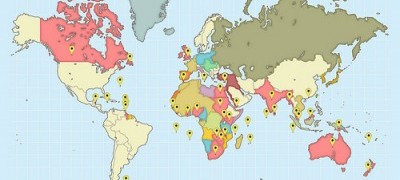
Screenshot of First World War: A global view
The First World War. What images spring to mind when you read those four words? Trenches? Mud? Young men, armed with bayonets, charging into machine gun fire? Poppies? These images of the horror of the Western Front have come to define what many of us think about this conflict. They tell a powerful and tragic story of death and waste across the heart of Europe.
But this is only one story, of a war that enveloped the whole world. What happened in countries and territories as far from Flanders’ fields as it is possible to go: from Ascension Island to Burma, Zanzibar to Newfoundland, Cyprus to Hong Kong? How did experiences and perceptions of the war differ in these far-flung corners of the world?
Here at The National Archives, we hold records on the First World War from across the globe. We wanted to represent the global nature of the conflict, and feature these records. Out of our discussions came the idea of a map, which would enable users to explore our records in a visually engaging and intuitive way, as part of our First World War centenary programme.
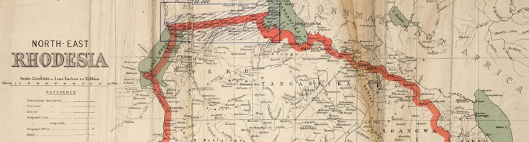
Map of Northern Rhodesia and Angloan Boundaries 1917 (WO 408/43 (14))
Today we are launching that map The First World War: a global view, which presents the events of the First World War as told by our records across the world. At this first stage, we are releasing the map with countries and territories from the British Empire in 1914. This is a four-year project, and we will expand on this content to include Europe, the Middle East, the Americas, Africa and Asia.
Through our map you can read about the drawn-out campaigns in East Africa, where British and German forces fought in difficult and remote environments. Find out which Caribbean island donated £250 worth of guava jelly to convalescing troops, and why 100,000 Chinese men were put on ships to Europe. Why did some German prisoners of war in Bermuda complain about the lack of stern discipline, and why did an American tourist visiting the island get shot in the foot? Discover individual tales of bravery, including the wife of a sheep station manager in the Falkland Islands, who recorded the positions of approaching German warships and telephoned them to the authorities.
To use the map, select a country or territory by clicking on a marker on the map, or select the name from the list. Navigate through the tabs to find out about to read about key battles, life on the home front and much more. Click on the references to find key documents in Discovery, our catalogue.

Anglo Japanese Naval Operations against Tsing-Tau, 1914 (ADM 137/35 f. 328)
Each country or territory is illustrated with images, maps and other documents from our collections. We found the images either within our image library, but more often within records found by searching Discovery. The criteria we used was the images had to fall within the time period of the war (1914-1918). In the case of maps, if they were of an earlier date, they had to have been used and altered for use during the war, within the 1914-1918 time frame. The only images we used outside these dates were photographs of war memorials commemorating the First World War and inaugurated a few years later.
We found a wealth of wonderful drawings, maps, plans, paintings and photographs (some of which we’ve featured here). Many of these can’t have seen the light of day since they were filed away, and as a result, are often in perfect condition. We chose the images subjectively mostly for their content, imagery and appeal. The size and quality were also considered for the technical ease with which they could be enlarged or reduced.
We searched by country, initially often ordering files in the hope they contained images of interest, rather than being certain they would. We came to a lot of dead ends but at the same time, as you can imagine, it was very exciting coming across previously hidden gems.
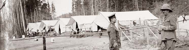
Inspection Dominion Detention Camp at Emerald, BC, Canada (FO 383/240)
We hope that these images will entice the viewer to find out more about the countries they represent, and that they will showcase the wonderful variety of documents we hold, either through the image library or through the records themselves.
We hope you enjoy exploring our records through the map. Please let us know what you think of it in the comments below.
Whilst most of the icons appear to be where you would expect them to be, the one for Australia is located at Alice Springs rather than Sydney or Canberra (I can’t recall when the A.C.T. was established, possibly in the 1920s).
Hi David,
Thanks for your comment. The markers simply indicate the location of countries or territories, not any specific cities or regions within them. We placed the markers where we felt they would be most clear (so generally towards the centre of the country/territory).
Thanks,
Alexa
Alexa, Sally
Thanks so for much for this. Fascinating and such an innovative resource/project. My knowledge of events during the Great War outside of Europe is rather limited, and the map provides such a vast amount of information in such an accessible format. Brilliant. I look forward to revisiting!
Jane
Hi Jane,
Thanks so much for your comment, we’re so glad you find the map interesting and easy to use!
Best wishes,
Alexa, on behalf of the whole map team
[…] The First World War: a global view […]
What about Mesopotamia and Palestine? These are so often forgotten in the memories of WW1, and it is not easy to find out more about them.
Hi Tina,
Thanks for your comment. This first phase of First World War: A Global View focuses on the contributions of the countries and territories that made up the British Empire during wartime, and Palestine and Mesopotamia were not part of the British Empire during the war. Palestine was assigned to the UK in 1920 under a League of Nations Mandate, and while the UK was also selected as mandatory power in Mesopotamia in 1920, Turkey didn’t renounce sovereignty until 1923.
We will continue to develop the map over the next four years, to show more countries and territories across Europe, the Middle East, the Americas, Africa and Asia. Palestine and Mesopotamia will therefore be added at a later stage. We will announce when the additions are being made to the map, so please do keep an eye out.
Thanks,
Alexa
[…] Click here for more […]
[…] National Archives (Britain): A global view featuring Africa amongst other areas and Wartime diplomacy: the role of the Empire (podcast) Other […]
First off A big THANK YOU to all who have participated in putting more information on line pertaining to WW1. A wonderful job well done.
I had been able to obtain my father’s Attestation Records some time ago. I am truly thankful in getting more information about my father over the past months, I know he was in France for 1 year 31 days I would like to know as much as I can about his time spent in France and exactly where he was while in France. I hope that someone will be able to provide me with this information and any other information that would be available while he was in the army.
My father Walter John Talbot, born 1898, Draycott in the Clay, Hanbury, Stafford
Royal Horse & Royal Field Artillery
Unit Battalion: 2nd Battery, 4th B, 1st A Reserve Brigade, No 1st Depot
event year 1916
Series: WO 363
Service number: 141303
Other records for this soldier service number; 896165 Regiment Royal Field Artillery 1916. I look forward to a reply at my home e-mail address listed above.
Joan P. Talbot-Wegert
Hi Joan,
Thank you very much for your comment, we’re really glad that you like the map.
Unfortunately at the blog we are unable to offer you research help – please see our research guidance at http://www.nationalarchives.gov.uk/records/. You can also contact our records experts using the form at http://apps.nationalarchives.gov.uk/Contact/contactform.asp?id=1 , or send a question to one of our Live Chat sessions (http://apps.nationalarchives.gov.uk/Contact/#livechat), and someone will assist you.
Best wishes,
Alexa